By: Assistant Chief Michael Fronimos
Wytheville Fire & Rescue Department
Population density, advances in lightweight construction, and ever decreasing manpower are wreaking havoc on the fire service. Fire departments are fielding more calls with less firefighters in areas that are nearly always being developed, built-up or renovated. It seems like every time you turn around, a new house or strip mall is going up on a tiny parcel that used to contain trees or a tiny legacy home.

The reality is, many of our jurisdictions now include multi-story, stick-built housing units on residential streets; heavy timber construction buildings converted to luxury residential apartments; chemically-intense light industrial operations adjacent to schools, nursing homes and residences; warehouses that have been subdivided multiple times with little oversight; or 10,000+ square foot residences with 20 foot ceilings. The hazard profile in a modern community is endlessly complex.
The fire service, both career and volunteer, are rapidly reaching the point where we need an advantage. Gone are the days where a jurisdiction included a few hundred fire hydrants, single-story commercial structures and single-family wood frame homes. In other words, the days when seasoned firefighters and command officers could keep track of most of their hazards with memory alone.
We have built ourselves up to the point where the fire department is always behind the ball when dispatch comes out. Now, command officers are making a majority of their tactical decisions after arriving at the scene. Let’s be clear, this is not due to lack of training or experience, as today’s firefighters are the best trained in history.
Our problem is a lack of information, along with how to collect it, manage it, and access it when a fire occurs. That’s right, we’re talking about pre-incident planning for an entire jurisdiction.
If there’s one thing every Incident Commander wants more of, it’s information. At dispatch, the IC is gathering information; enroute to the call, the IC is scanning the sky and mentally ticking off what they need; pulling into the block, the IC is looking for hydrants; pulling up, the IC is doing a 360, checking exposures, fire progress, potential victims, the list goes on.
Incident Commanders are at a constant and perpetual need for information.
Now, the information does not mitigate the incident, nor does the information dictate exactly what to do. It is up to the IC to plan and execute their mitigation strategy based in part on the information they gather, the resources available, and their training and experience. Or, exactly the same way we’ve been fighting fires for centuries.
Preplans are information goldmines.
NFPA 1620, The Standard for Pre-Incident Planning, sets minimum basic guidelines for a pre-incident plan. These include physical site elements, occupancy type, water supply, hazards, construction features, target fire flow, etc. More robust preplans include images of the structure, floor plans, detailed construction features, contact information, hours of occupancy, etc.
Effective preplans tell an IC, in advance, that a high volume hydrant is across the street; or that the building is constructed with a open-web wood truss roof; that this building has a residential apartment on the second floor only accessible from a rear stairwell; or that the basement extends under the store next door. The list of fire service concerns that could be on an effective preplan are virtually endless.
Remember that problem with developed jurisdictions? Memory can only take us so far.
Preplans do not reinvent the wheel. They just make it better.
So what’s wrong with “we didn’t have preplans before, why do we need them now”?
Well, when Thomas Edison invented the electric lightbulb he became the regular subject of New York Times cartoonists, and they relished in mocking his “absurd” ideas. A member of British Parliament felt strongly enough to claim that Edison’s ideas were “unworthy of the attention of practical or scientific men.” Ironic, no?
Pre-incident plans, like a shining light fixture, won’t instantly solve everything. But if the problem is a working fire, or a dark room, having it readily accessible can be an enormous advantage.
And yet, fire departments are either creating preplans only to not use them, or they aren’t creating them at all.
Why?
Because there was no way to collect the plan in just a few minutes, store it in a place where any firefighter can access it from anywhere, at any time, and access the plan in seconds with little thought.
Emphasis on “was”.
In 2019, there is an app for virtually everything. If we have any questions about anything we turn to Google. We use social media to keep track of our friends, and most of us have only memorized a handful of phone numbers. Connected smart devices allow us to collect, manage, and access all the ‘data’ behind our daily lives.
So is there a Facebook/Google of firefighter preplans?
Yes. FlowMSP.
Let’s examine this point by point.
Traditional preplans can take hours to collect, for each building planned. Naturally, this means that only the highest-hazard structures receive plans. And creating each plan is an endeavour that requires pen, paper, camera and tape measure.
FlowMSP was designed for firefighters with firefighter input, so every effort was made to reduce the amount of time it takes to create preplans. With any connected mobile device (smartphone, tablet, etc.) firefighters can create a basic NFPA 1620 preplan in less than 10 seconds. Using the camera on their device, firefighters can then add pictures of the structure, special hazards, approaches, access points, etc. The list is endless.
Each image can be annotated with labels, words, drawings, etc., so firefighters can mark alarm panels, utility locations, knox box locations, gate codes, FDC locations, standpipe locations, etc. And because the platform operates natively with Google Maps, every interaction with the software is displayed on the satellite imagery in Google Maps, along with all the additional information offered by Google (business names, street names, addresses, search features, etc).
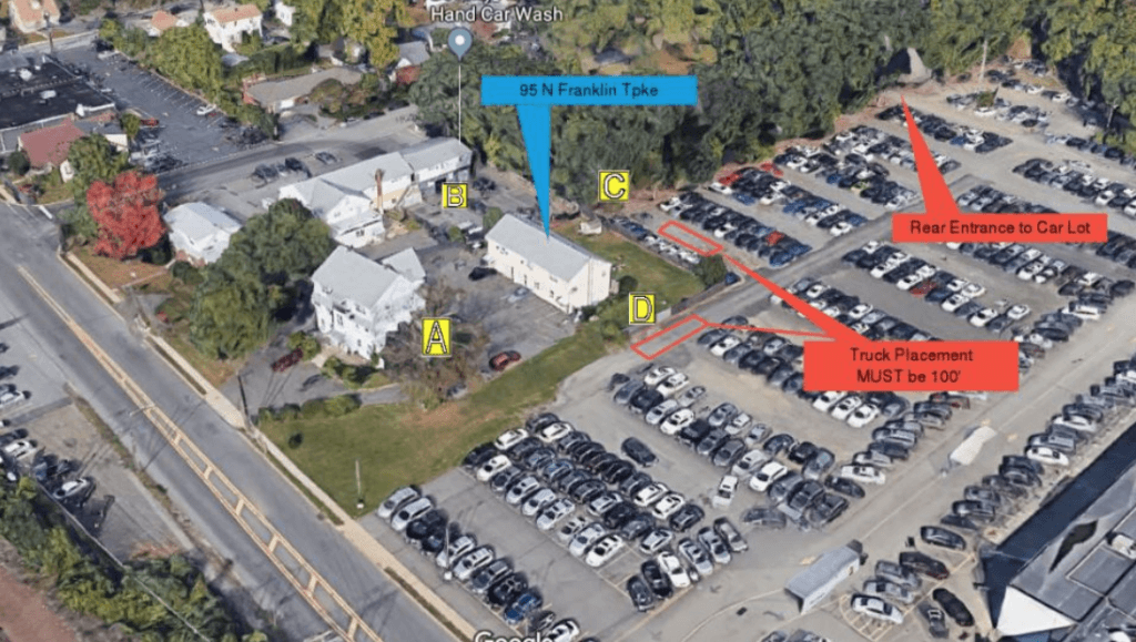
With minimal input, FlowMSP automatically determines building address, calculates building square footage, target fire flow, and selects the nearest fire hydrants to match that required flow rate. That’s right. FlowMSP displays fire hydrants too.
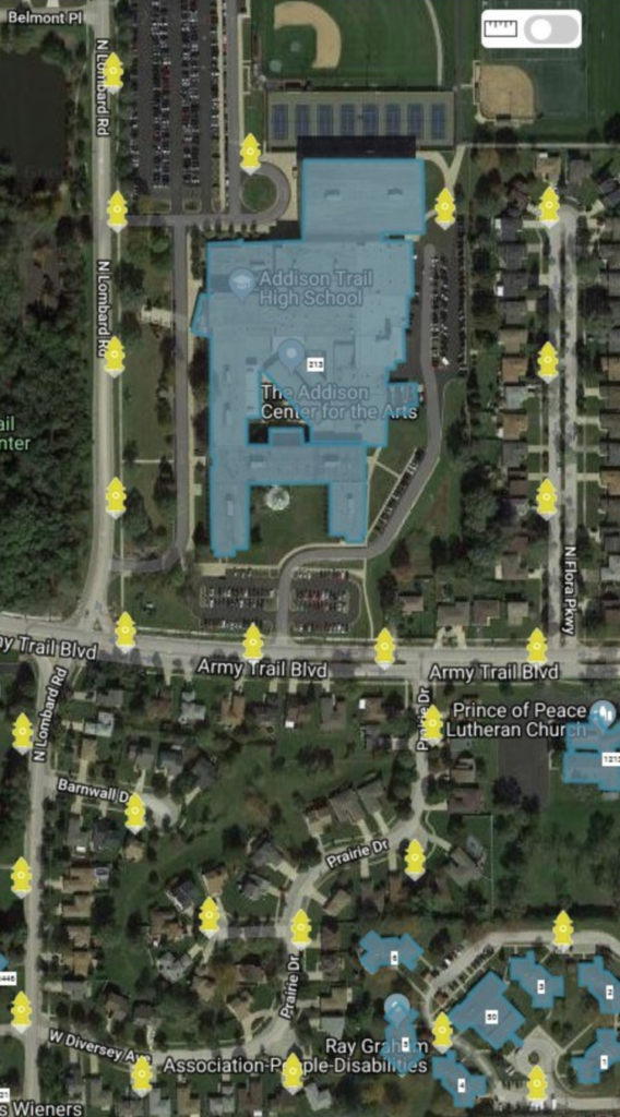
Have you ever been in a situation where you really needed a fire hydrant but wasn’t sure where the nearest one was? Not anymore. FlowMSP will integrate all your fire hydrant data directly into the platform, showing the exact location of each hydrant NFPA color coded for volume.
No more guessing where the nearest hydrant is.
Just look at the map.
As we’ve discussed, a major downfall with traditional preplans is what to do with them. Some departments keep their preplans in binders that reside in a command vehicle, the first due engine, or even in an office. As the plans grow, the binders get bigger and more numerous. Labeling becomes difficult, and it gets harder and harder to determine what plans have been done, what plans need to be done and what plans need updating.
Speaking of updating, NFPA 1620 recommends updating preplans once a year.
Now some departments have moved towards creating electronic plans, and storing those plans on a flash drive, or cloud drive. While that is definitely a step in the right direction, plan access is still limited by whoever physically has the flash drive, or access to the cloud drives.
FlowMSP maintains all preplan data in the cloud, just like your email, so it is accessible from any device that can access the internet. The only requirement is a login and password. All preplans are also time and date stamped, and reports can be generated showing which plans are due for updating.
Finally, there is no labeling process or file names. Creating preplans in FlowMSP means selecting the actual building to be planned on the map. The plan file location is then tied to that actual location. Need to locate a plan? Just put in the address of the structure. Or find the structure on the map and the plan is there.
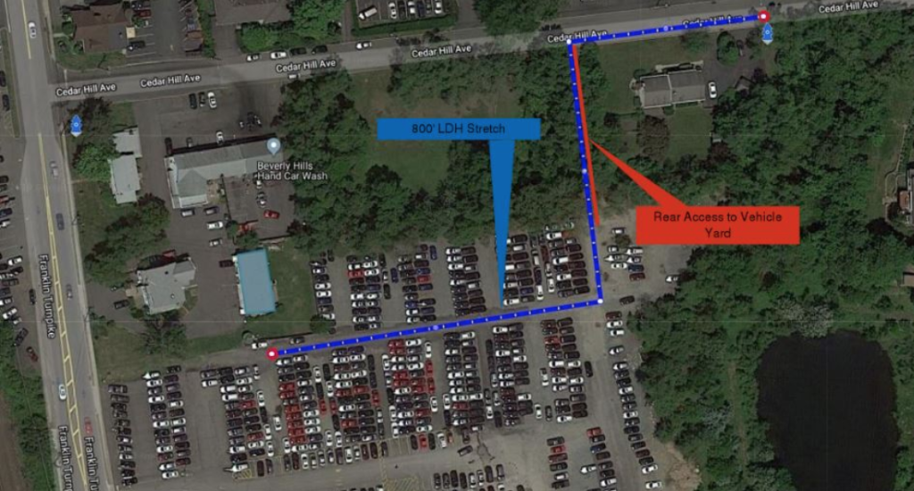
Let’s talk access.
This is the meat and potatoes of any preplan platform, and also the most difficult obstacle to overcome. Command officers do not have time to search for plans, read descriptions, or try and decipher terrible handwriting. There is simply too much going on.
In order to take the searching process completely out of the equation, FlowMSP turned to a source of information we all have. CAD messages.
FlowMSP integrates with nearly every CAD software platform, and will display those messages right in the platform. When a dispatch is received, command officers only have to click on the message and the platform will automatically display the preplan associated with that call.
Remember when we talked about command officers being behind the ball after a call is received? Well, now we can substantially decrease that disadvantage.
With a single click, command officers will instantly be viewing overhead Google satellite imagery of their call location, hydrant locations, hazards, approach considerations and building data. In many cases, command officers will be fully aware of their building and hydrants before even leaving their parking spot.
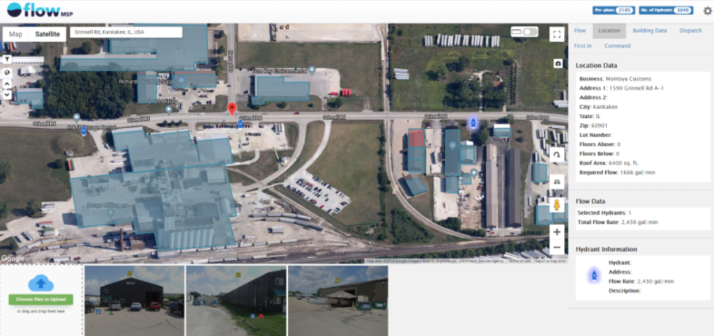
FlowMSP isn’t restricted to chief officers either. With internet access, everything the chief can see, the company officer in the apparatus can see. And the firefighters in the back of the apparatus, the firefighters still at the firehouse, the personnel at the dispatch desk, even firefighters at remote locations. If your firefighters can access the internet anywhere in the world, they can view your preplans and use the information to make well-informed decisions.
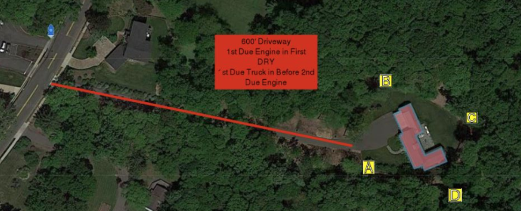
If a company officer arrives at the scene first, they can execute the preplan. If a non-officer is in the officer’s seat of a piece that arrives first at the scene, they can execute the preplan. If a mutual aid officer is enroute to your call and they are first, they can execute your preplan.
Wait, mutual aid too?
What good is valuable information if you can’t share it? Provided your mutual aid partners are also customers, they will see all your fire hydrants and preplans too. They can respond to your jurisdiction as if it was their own and make the same well-informed decisions you would make. In the reverse order, when responding to a neighboring jurisdiction with FlowMSP access, you can see their preplans and their hydrants.
As we’ve discussed, the modern fireground is a battle of information. A battle that the fire service is losing because our jurisdictions are changing faster than we can keep track of them. The real tragedy here is that lack of information is how terrible command decisions can be made, how firefighters can get hurt, and can substantially contribute to firefighters being killed.
Have you ever missed a closer hydrant? Not know where the nearest hydrant is? Responded to a fire and been continually behind the ball? Seen firefighters go to the roof with a chainsaw, not knowing the roof decking was metal? Ran a fire in a multiple-occupancy and not known where the firewalls were located? Sent firefighters on a wild goose chase to find the fire alarm panel, gas shutoff or utility panel? Wanted to place a second or third aerial in service but wasn’t sure if they could reach the structure?
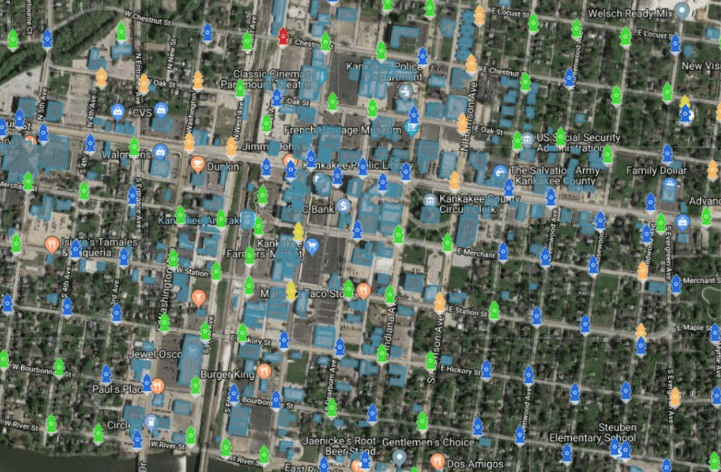
Why operate at fires with less information?
FlowMSP is extremely simple to learn and use; designed specifically to work for the seasoned firefighter and new firefighter alike. Access is as easy as being on the internet and adding preplans and data only requires a device nearly every adult in America has in their pocket: a smartphone.
How much better can command decisions be with more information?
The future is here, and we have the tools to manage the information NOW. And those tools are IN USE at departments across the country, helping firefighters make better tactical decisions.
YOUR department can join them.